
Category: Permaculture
You are viewing all posts from this category, beginning with the most recent.
cool story about harvesting wild plums
I may use some of these techniques on our wild berries (especially mulberries).
attending: Wild Hope for Salamanders
Wanna join?
When I was growing up, bugs often hit our windows when driving.
This is another one of those things that is a largely unremarked major change in our environment.
How many of these can you answer about the bioregion where you live?
It seems appropriate that these questions came up (during my daily highlights review) on a colonial holiday. May we re-orient ourselves to deep connection over superficial exploitation.
-
Point north.
-
What time is sunset today?
-
Trace the water you drink from rainfall to your tap.
-
When you flush, where do the solids go? What happens to the waste water?
-
How many feet above sea level are you?
-
What spring wildflower is consistently among the first to bloom here?
-
How far do you have to travel before you reach a different watershed? Can you draw the boundaries of yours?
-
Is the soil under your feet, more clay, sand, rock or silt?
-
Before your tribe lived here, what did the previous inhabitants eat and how did they sustain themselves?
-
Name five native edible plants in your neighborhood and the season(s) they are available.
-
From what direction do storms generally come?
-
Where does your garbage go?
-
How many people live in your watershed?
-
Who uses the paper/plastic you recycle from your neighborhood?
-
Point to where the sun sets on the equinox. How about sunrise on the summer solstice?
-
Where is the nearest earthquake fault? When did it last move?
-
Right here, how deep do you have to drill before you reach water?
-
Which (if any) geological features in your watershed are, or were, especially respected by your community, or considered sacred, now or in the past?
-
How many days is the growing season here (from frost to frost)?
-
Name five birds that live here. Which are migratory and which stay put?
-
What was the total rainfall here last year?
-
Where does the pollution in your air come from?
-
If you live near the ocean, when is high tide today?
-
What primary geological processes or events shaped the land here?
-
Name three wild species that were not found here 500 years ago. Name one exotic species that has appeared in the last 5 years.
-
What minerals are found in the ground here that are (or were) economically valuable?
-
Where does your electric power come from and how is it generated?
-
After the rain runs off your roof, where does it go?
-
Where is the nearest wilderness? When was the last time a fire burned through it?
-
How many days till the moon is full?
The Bigger Here Bonus Questions:
-
What species once found here are known to have gone extinct?
-
What other cities or landscape features on the planet share your latitude?
-
What was the dominant land cover plant here 10,000 years ago?
-
Name two places on different continents that have similar sunshine/rainfall/wind and temperature patterns to here.
Public Service Announcement: USDA Plant Hardiness Zones have been updated to reflect climate changes.
It may be worth rechecking what you can cultivate in your area.
Speaking of plastic reduction, I’m enjoying Alpine Provisions.
I may switch to getting all toiletries there, rather than the variety of places I am now (Bite, Mad Optimist, Bronners).
Indiana lawmakers could further dilute state wetlands protections following SCOTUS decision
As our weather gets worse, politicians do, too?
🕊️♻️ Good workshop on Climate Anxiety, Hope, and Resilience this morning. #MennoCon23
Once again I made the call to reorient our conferences and districts to our watersheds.
An Alternate Geography
I live in the:
- Nation of Ohio
- State of Wabash
- County of Patoka-White
- City of Upper White
Let’s reverse that order, starting with Upper White and zooming out:
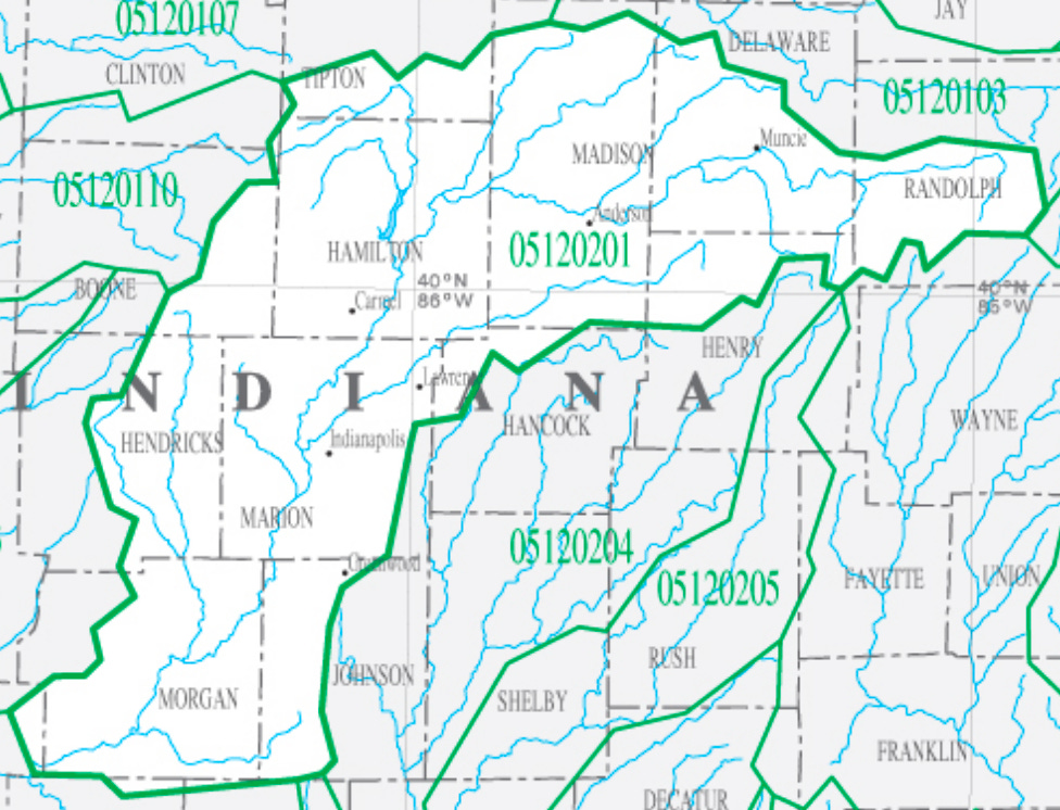
Upper White:
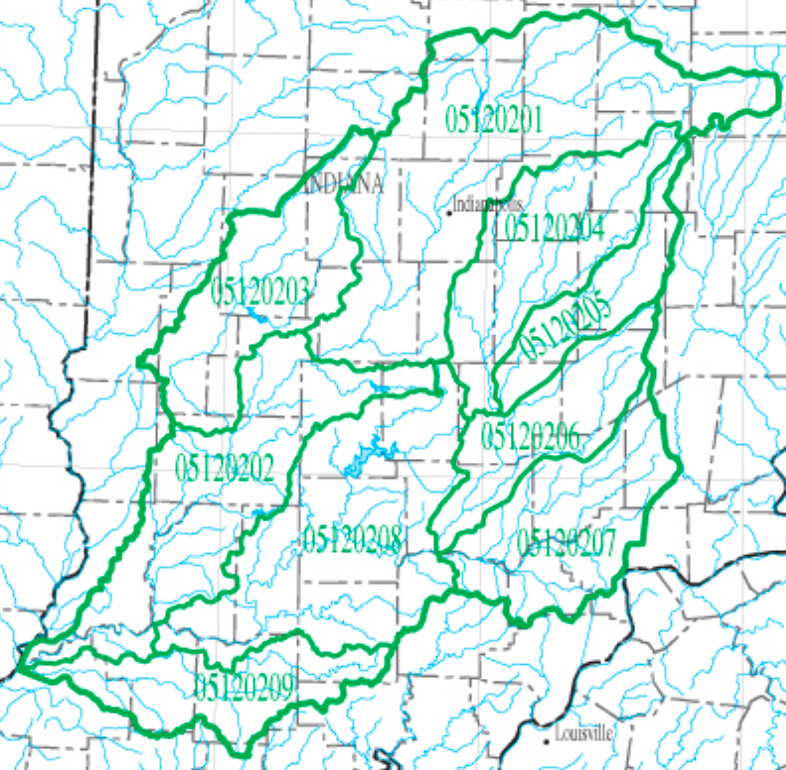
Patoka-White:
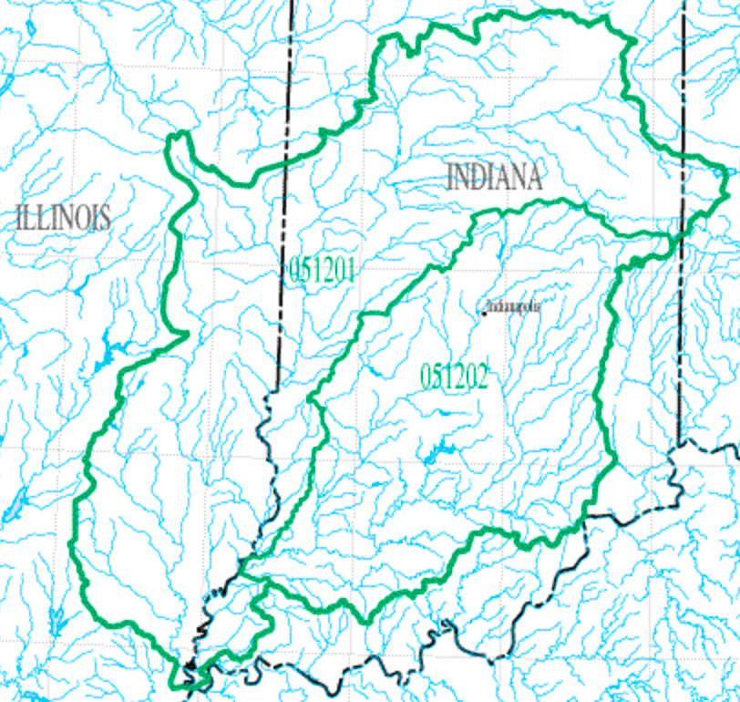
Wabash:
Ohio:
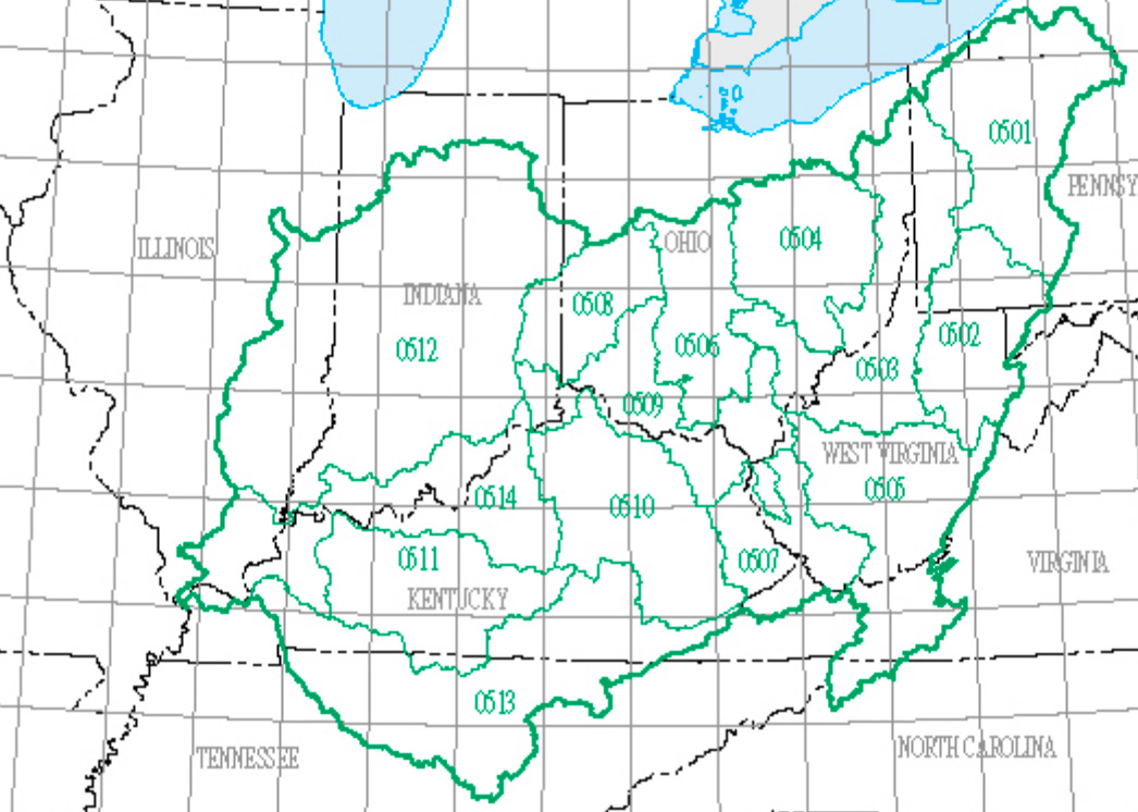
Ohio and neighbors:
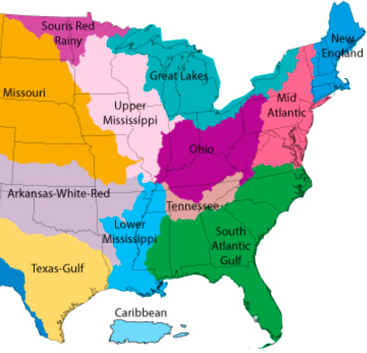
images sourced from: [https://water.usgs.gov/wsc/map_index.html](https://water.usgs.gov/wsc/map_index.html)
What are these?
These regions are “watersheds” or “drainage baisins”. They represent an area where all the water drains into one body (stream, river, lake, etc.).
In the USA, the numbers you see in the above images represent the 8-digit “HUC” or Hydrologic Unit Code. From my example, 05120201 represents Ohio (05), Wabash (12), Patoka-White (02), Upper White (01). As you can see, they are all named after the major river(s) of that region.
In addition to the 8-digit HUCs, there are also 12-digit HUCs, representing two additional layers of zoom-in and specificity. Using my proposed naming above, perhaps we could call these Townships and Neighborhoods.
What are mine?
In the USA, you can find your regions by progressively zooming in via this tool from the US Geological Survey. For each region, they also provide many linked resources.
To get even more specific, you can check your 12-digit HUC using the community water search from the EPA. This is also a great resource to see the quality of the water in your area, including the safety of swimming in it, the health of aquatic life in it, and the quality of your drinking water.
(Note: if you live outside the USA, please feel free to share in the comments how to look up watersheds where you live!)
Why does it matter?
As the saying goes: water is life. People, wildlife, and the entire ecology within a watershed are all part of the same stream of life.
In addition, ecological health is tied to financial health, and both are affected by community interactions and governance within the region. Their fate flows together.
Thus, the thought experiment of using the terms: Nation, State, County, City, Township, Neighborhood.
Political boundaries can often feel arbitrary, based on agreements or impositions that may have had very little to do with the people that actually live in the area (or were even contrary to their interests, such as in colonial situations).
But watersheds are based on shared life. Regardless of wealth, ethnicity, or other factors, people within a watershed have shared destiny.
So what?
What would it mean to think of our local watershed as our polity, our political unit?
Could we become better at seeing our neighbors as people in the same boat, rather than as enemies?
Could we more readily identify how systems are interacting?
Could it enable more long-term thinking, strategic thinking, thinking that considers not just the current moment but the impact to the financial, social, and ecological health of the region?
How is the health of your watershed? What might you do, knowing that?